THE PILBARA
 The
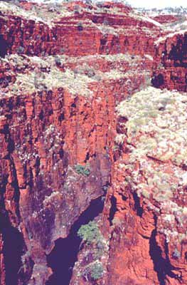
Pilbara is the region immediately to the west of the Kimberley. It
contains some of the most interesting and least known bushwalking
country in Australia. Most of our trips take place in Karijini
National Park and the Hamersley Ranges where deep, spectacular,
red-walled gorges hide magnificent pools and waterfalls. We occasionally run trips in the little-known Chichester Range in
Millstream-Chichester National Park where we explore deep into the
heart of the range seeking out hidden pools and gorges which will
remain forever unknown to non-walkers. Our Pilbara trips depart from Tom Price.
The
Pilbara is the region immediately to the west of the Kimberley. It
contains some of the most interesting and least known bushwalking
country in Australia. Most of our trips take place in Karijini
National Park and the Hamersley Ranges where deep, spectacular,
red-walled gorges hide magnificent pools and waterfalls. We occasionally run trips in the little-known Chichester Range in
Millstream-Chichester National Park where we explore deep into the
heart of the range seeking out hidden pools and gorges which will
remain forever unknown to non-walkers. Our Pilbara trips depart from Tom Price.
Click here to see a photo gallery from our 2001 Karijini trip. Please be patient while the photos load.
Click here to visit the Australia's Northwest Pilbara page. This has a wealth of information about the region.
Our April and June-July Pilbara-Karijini tours depart from Tom Price. The Tom Price Tourist Buerau website has more information about the town and the area.
Weather
The Pilbara climate is similar to, but somewhat warmer than that in the Red Centre. Winter is the most comfortable time, so all our trips take place during winter.
If you would like detailed information about the weather in the Pilbara, try these links from the Bureau of Meteorology.
For an easy to understand graph showing average temperatures and rainfall, click "Graphs".
For a detailed table of climate averages, click "Tables".
For a picture of recent rainfall so you can see what the current or last wet season is or was like, click "Rainfall" and choose which ever map or maps you would like to see.
| Rainfall |