THE TOP END
The Top End is the northern portion of the Northern Territory,
an area containing some of the best bushwalking areas in the
world.
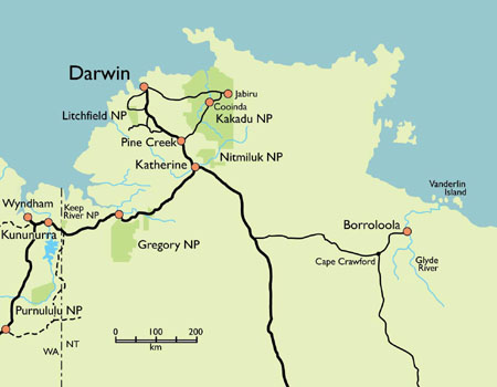
In addition to Kakadu (Australia's largest national park and our most popular destination), we offer trips to Nitmiluk, Litchfield and Gregory National Parks plus Arnhem Land and the Carpentaria region near the town of Borroloola.
Weather
Our seasons are different -- no winter or summer here. The wet season (December-April) is a time of waterfalls and wildflowers. The warm rain is a pleasure to walk in, something that must be experienced to be believed. The dry season (April-September) brings clear skies and pleasant temperatures, weather so reliable that few people carry tents. The thunderstorms and sudden greening of the land make the Build Up (September-December) the most dramatic season of all.
Three seasons? The Aboriginal people in the northern part of Kakadu distinguish six seasons. The Jawoyn people in the southern part of the park and near Katherine distinguish five. If you want to understand our weather, we strongly recommend that you have a good look at the links in this paragraph.
http://www.environment.gov.au/parks/kakadu/nature-science/seasons.htmlWant more info about our weather? Try these links from the Bureau of Meteorology.
For easy to understand graphs showing average temperatures and rainfall, click "Graphs". Jabiru is in the northern part of Kakadu. Katherine is just ourside the southern boundary.
For detailed tables of climate averages, click "Tables". Jabiru Airport and Katherine Council are the best for Kakadu. Timber Creek is the best for Gregory National park.
For a picture of recent rainfall so you can see what the current or last wet season is or was like, click "Rainfall" and choose which ever map or maps you would like to see.
| Rainfall |
For more information about bushwalking in the wet season, click the link below.
For more information on Kakadu and a park map, click the Kakadu link below. For more information on other parts of the Top End, click the Top End Link.
To find out how to get to Darwin, click here. |