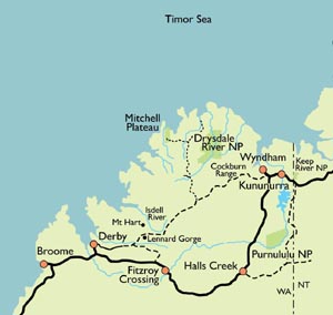
THE KIMBERLEY
The Last Frontier
 The
Kimberley is big. It is larger than the Australian states of Victoria
and Tasmania combined, larger than Texas in the USA, almost as big
as Germany or Italy.
The Kimberley is empty. It is home to less than 30000 people, most of whom are concentrated in a few small communities. There is only one sealed road which passes through it. Many of the gravel roads are impassable during the wet season. One of these roads, the Gibb River Road is one of the best known 4WD destinations in Australia.
The Kimberley is spectacular. This is a land of rugged mountains, spectacular waterfalls and mighty rivers that could fill Sydney Harbour in a matter of hours. The Kimberley's incredible cliff-lined coast is one of the most beautiful in the world.
The Kimberley is wild, wonderful and full of surprises. It contains an amazing
number of Aboriginal rock art sites. There
is a variety of vegetation, much relatively unstudied. The animals
are less shy and easier to see than in Kakadu. Fishing is
excellent.
The Kimberley climate is similar to that in the Top End: a warm,
wet season (December-April) when waterfalls appear everywhere and
wildflowers carpet the land, a dry season (April-September) when
the weather is absolutely perfect and a Build Up
(October-December) when it is so hot that we do not run any
trips.
Click the link above for detailed information about Kimberley weather.
There is no one else! There are dozens of tour operators who can show you parts of the Kimberley. Willis's Walkabouts is the only one who takes you far from the tracks and shows you wonderful places which can only be reached on foot.
The Kimberley can't be described in a single page. The Bungle Bungles; the Mitchell Plateau; the Charnley, Drysdale, Durack, Isdell and Ord Rivers; the Carr Boyd, Cockburn and Osmond Ranges -- and more. Every one of these wonderful places needs a page of its own. Click here for more information.
To find out how to get to the Kimberley, click here.
Here are some good links for general information about the region.
The Kimberley Tourism website contains a wealth of information, towns, climate, maps, visitor information and more. We do, however, stongly disagree with their listing only two seasons when they talk about climate.
The Western Australian Tourism website contains information about the whole state.